The Yellowbelt
Thanks to Gil Meslin for his input.

The term 'Yellowbelt', coined by urban planner Gil Meslin, describes a large swath of land that is designated as 'Neighbourhoods' in the City of Toronto's Official Plan. The Yellowbelt could be defined by several residential zones and by-laws, but, as Sean Galbraith points out, the primary zone within the Yellowbelt is the Residential Detached (RD) zone - defined in the city of Toronto Zoning By-Law as areas that prevent higher-density development (through maximum height of 10 metres) and permit only detached residential housing:
10.20 Residential Detached Zone (RD) - In the RD zone, a dwelling unit is permitted in the following residential building types: (A) Detached House.
The term Yellowbelt is a reference to the Greenbelt (1.8 million acres of protected farmland and natural heritage in the GTHA) and its role as a restriction on new development for the purpose of preserving existing land uses and natural features. These 'stable' neighbourhoods restrict alteration of their streetscapes by limiting the types of housing that can be built, and therefore limit access to these areas to those that can't afford the high-value, low-density housing types. While there has been monumental high-density housing development in recent years, the European style walk-up apartment and mid-rise development, the so called 'missing middle', have been less popular with developers due to the lower number of units per developable hectare and lower profit margins. Therefore, developers may be left with limited options: either pay high prices for arterial fronting lots and develop towers to offset land acquisition costs or develop luxury single family homes in stable neighbourhoods.
City Councillor Gord Perks recently said the City has begun to address this policy issue through Official Plan Amendment (OPA) 320, which "amends the Healthy Neighbourhoods, Neighbourhoods and Apartment Neighbourhoods policies of the Official Plan..to protect and enhance existing neighbourhoods, allow limited infill on underutilized apartment sites in Apartment Neighbourhoods, and implement the City's Tower Renewal Program." While this OPA represents a significant change in the Official Plan, there are some limitations others have pointed out. Paul Demczak replied on twitter, "While policy 4.1.1 (from OPA 320) allows 4 Storey walkups, 4.1.5 states you cant introduce them into a context in which they are not currently represented," and then goes on to say, "This ensures predominantly detached and semi-detached neighborhoods will remain as such."
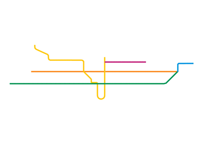
Detached and semi-detached residential zones

Mixed-use and other residential zoned areas

The Yellow Belt is large. It is approximately 1.8 times larger than the total land area of all other residential zones. Furthermore areas that are zoned for higher density development are largely contained within the old City of Toronto.
Height restrictions also add another layer of complexity. Below you can see how zoning height restrictions limit mid-rise development in many of these downtown areas.
Higher density residential areas in Old Toronto

Areas zoned for greater than 12 metres in height

While speaking with Gil Meslin, he pointed out that Yellowbelt policies are potentially contributing to higher housing prices, by limiting housing supply, in the short-term and creating further socio-economic inequality. In his words, these areas are becoming the "exclusive domain of the privileged few". By not allowing higher density development the City may be signiciantly limiting access to amenity rich (close to schools, parks, libraries, jobs and other public assets), well connected areas.
One way to limit the impact of Yellowbelt policies, is to zone for the "missing middle": a combination of mixed-use buildings and medium density housing types that increase residential densities while largely maintaining the look and feel of a neighbourhood.
Using 28 MacPherson Ave. (near Yonge and Summerhill) as an example, Meslin stated, "This building fits in very nicely on the street – and on a lot the size of three nearby houses. It provides 17 units, extends much farther back than its neighbours, and covers much more of the lot. What makes the typology work isn’t height, it is the mass hidden behind neighbourhood-scale façade, and this is common of the walk-up typology. The zoning by-law might allow the USE, but it won’t allow the FORM that is necessary to make that use viable."
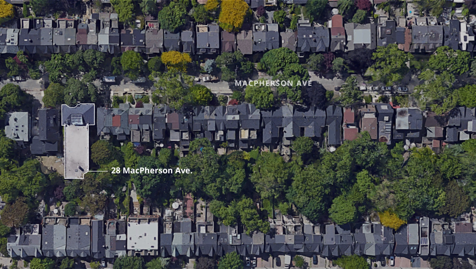
Aerial view of 29 MacPherson Ave. Source: Google Maps
Current policy may state that the city promotes more of this type of development, but it must exist as the 'prevailing building type in the area'. Meslin pointed again to the MacPherson example, "there are only two such buildings on the block – present, but hardly predominant – would that meet the ‘prevailing building type’ test?"
The webmap below shows the change in housing units, at the block level, from 2011 to 2016. The map also shows the residential zones within the city of Toronto (toggle). For a larger view of this map see our post here.
It's hard to point to another world-class city that has detached housing in such close proximity to its downtown core. Toronto is young, but it now has the opportunity to guide its development as a maturing metropolis and gently increase density across the majority of its residential space.
Source: Toronto's Open Data Portal